In February, City Council approved a zoning package that created three new base districts for Oakland and extended inclusionary zoning to all of our community.
We talked to Christian Umbach, Senior Planner at the Department of City Planning (DCP), about what was in the zoning package and what it means for the future of Oakland.
What are the new zoning districts?

1. Fifth and Forbes Avenue corridor
Old District: Oakland Public Realm District, Subdistrict C
New District: Urban Center—Employment (UC-E) (Aligns with the “Innovation District” classification from the Land Use Strategy)
This area functions as both a high-capacity transit corridor and Oakland’s central hub for employment and institutional-related uses.
New provisions better support such uses by including a predictable pathway for creating taller buildings, new open space, wider sidewalk standards, and limits on new residential development to create more space for jobs. The aim is to support Oakland’s innovation economy with more opportunities for business incubation, workforce development, and R&D.

2. Boulevard of the Allies
Old District: Oakland Public Realm District, Subdistrict D
New District: Urban Center—Mixed Use (UC-MU) (Aligns with the “Mixed Use Area” classification from the Land Use Strategy)
The Boulevard is a prominent roadway with high visibility and access, yet it remains largely underdeveloped and lacks pedestrian-friendly infrastructure.
New zoning supports more dense mixed-use development around the Boulevard, including neighborhood-serving business incentives for the construction of new affordable housing.

3. Central Oakland between Louisa Street and Dawson Street
Old District: multiple residential zoning districts
New District: Residential—Mixed Use (R-MU) (Aligns with the “High and Medium Density Residential” classification from the Land Use Strategy)
Some existing housing is limited in size and substandard in quality, partly due to the division of previously single-family homes into student apartments.
R-MU allows for new multi-unit housing structures that can better meet student and affordable housing needs, while supporting neighborhood-serving commercial and the creation of new open spaces.
Plus, the Inclusionary Zoning Overlay District
Oakland joins Lawrenceville, Bloomfield, and Polish Hill in the IZOD, which requires all new or renovated developments with 20+ residential units to provide at least 10% of units at an affordable rate relative to regional income levels.
Why have new zoning districts?
In short: Oakland is an active and dynamic area with strong demand for housing and employment spaces, both fueled by a large university population and a growing innovation economy. Revamped zoning districts were needed to accommodate that growth and relieve pressure on surrounding single-family residential areas. New zoning also works to ensure that new developments are high-quality, contextual to Oakland, and provide benefits to the community.
Further context: Zoning proposals were informed by public engagement during the creation of the Oakland Plan (2020-2022). Throughout many discussions, three top goals emerged, including the 1.) need for more affordable and well-designed housing, 2.) desire for more jobs accompanied by workforce training, and 3.) provision of more open spaces to enhance quality of life.
These goals informed the plan’s Land Use Strategy, which is the desired vision for how future development should look and feel in Oakland (e.g. types of uses [housing, commercial, office, etc.], building height, density, character, etc.).
Zoning is one tool that works to help realize the Land Use Strategy by setting specific regulatory standards for developments, such as the types of uses, the size of buildings, and how buildings relate to public areas. The three new districts are a response to the Land Use Strategy and top goals of the Oakland Plan.
What changed compared to the previous zoning?
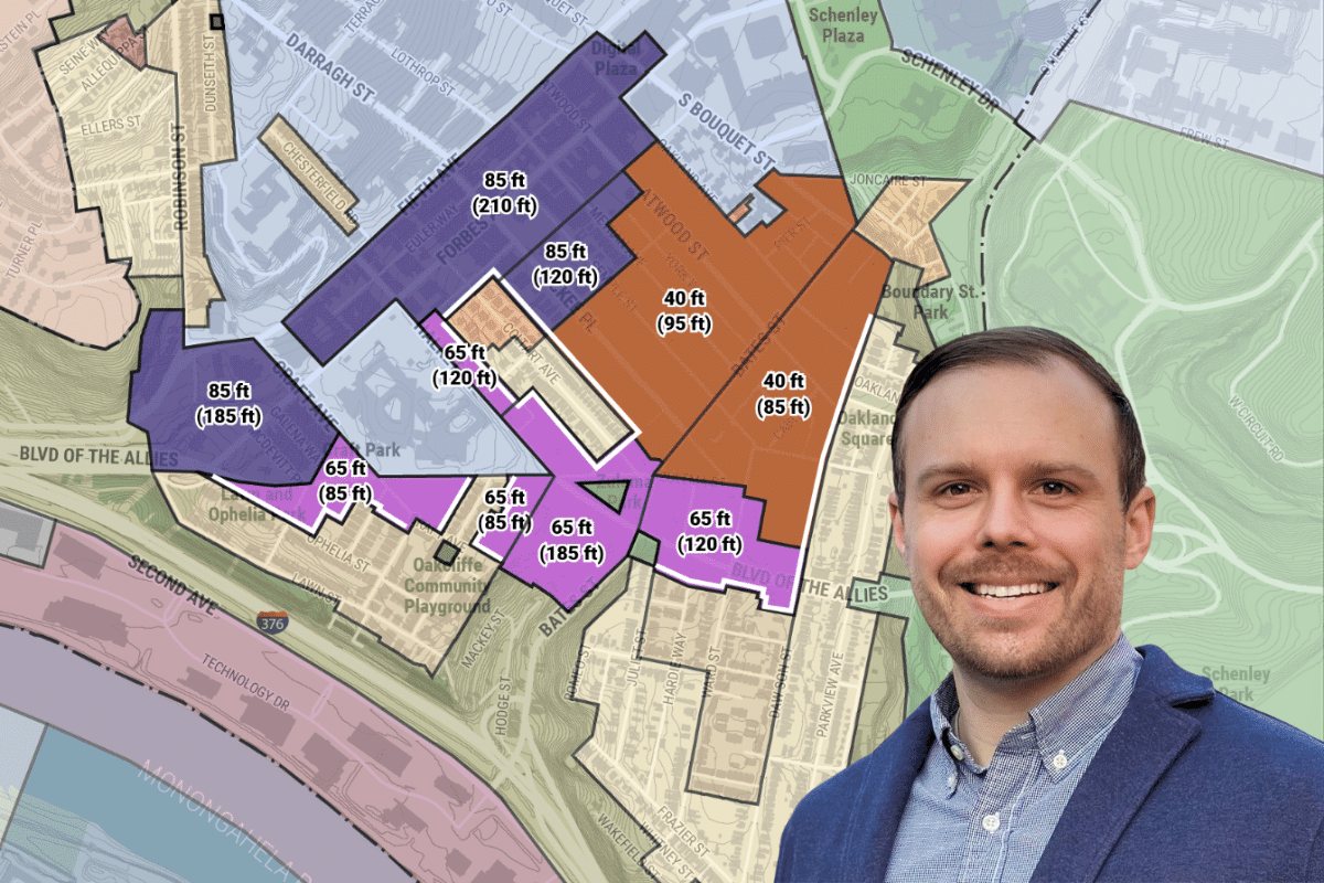
Zoning changes are generally limited to Oakland’s central core:
Along the Fifth and Forbes corridor from the western gateway (376 parkway ramp) to Bouquet St.
Along the Boulevard of the Allies corridor from the western gateway to Dawson St.
Throughout parts of Central Oakland bound within Louisa, Bouquet St, Dawson St, and Halket St.
Throughout these areas, amendments generally represent even and incremental changes to existing zoning regulations and are based upon the land use strategy which aims to respect the existing context and character block by block.
The zoning for all other areas (including much of the residential portions of North, South, and West Oakland) remains unchanged. The Oakland Plan does call for additional zoning amendments for other parts of Oakland that may be pursued in the future.
What is possible in each district?
This is where we do get into some of the details. We are currently working to update the project EngagePGH webpage with the final Council-adopted ordinance materials, including a table of uses allowed in each district, maximum permitted building heights, as well as the visual scale of buildings and buffering between neighboring properties. We will update OPDC when these items are available online.
How can developers gain special permissions?
The Zoning Code provides for a Performance Point System that allows projects to earn additional building height in exchange for providing community benefits such as affordable housing, public art, and energy-efficient design. Learn more about Performance Points.
How soon will we see the effects of the new zoning?
While we anticipate greater building in response to the expanded zoning permissions, developments take time to be fully realized, especially when considering variable market conditions as well as the months of planning, design, and review processes before any groundbreaking.
Keep in mind, that each project will have its own Zoning Code review process, including an opportunity for community members to provide input at Development Activities Meetings and at Planning Commission hearings.